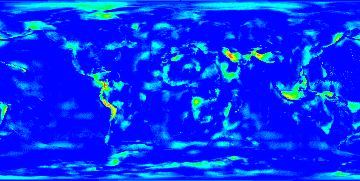
The height correction 'corrected' ;-).
 BT747 corrects the altitude/height logged by the logger to an altitude with as reference the mean sea level. Stefano complained that this correction was not precise enough. The error can indeed go up to more than 40 meters in some locations. That is because the 1.X versions use values at the crossing of a 10°x10° grid fitting of the world. Following our fruitfull discussions, Stefano extracted the 1°x1° grid data. The differences with the 10°x10° model is shown in the picture. Blue is almost no error, red is 25 meters or more (in GE.) The red areas are quite slim, so this can indeed not be captured in the coarse model. Some green areas might be improved in the coarse model. This precise data is now integrated in the Desktop version of BT747 in the 2.X development version. I though you might want to know the error that you face with the 1.X version: not too much overall. You can examine the error more closely by opening the image as an overlay in google earth.
- Anmelden um Kommentare zu schreiben
Kommentare
Problem solved
2.X.1395 solved precise height calculation issue.
When compiled the precise values were not loaded completely resulting in '0' in most areas. The problem was a misinterpretation of the effect of a 'read' method on a stream in Java. The 'read' was partial in stead of complete.