mdeweerd's blog
BT747 2.3.1 Released - Map Functionnality Updated
Mon, 03/29/2021 - 11:26 — mdeweerdBT747 has been updated to cope with new requirements from map providers.
The list of available map providers has been reduced to list only relevant ones.
To limit the requests to these free providers, set a local cache directory from the File menu. You be able to access previously fetched tiles offline as well.
New AGPS URL
Sun, 08/05/2018 - 03:26 — mdeweerdA new version of BT747 was released integrating a new AGPS download location.
The application has also been signed with a new signature, https://soft.bt747.org has been updated with these signatures and the jnlp files have been updated to use https.
BT747 - New code signatures
Sat, 02/13/2016 - 15:41 — mdeweerdThe code signing key used for BT747 had to be upgraded to SHA-256.
Unfortunately that also revoked the old key and apparently the timestamping was not properly done with the previous signatures. So the java laucher complains that the certificate is revoked.
All files have been resigned and republished.
You may need to launch:
javaws -viewer
[on windows : "Windows Key + R" to access the execute popup where you can enter this].
Is your GPRS Tracker safe ?
Mon, 12/13/2010 - 01:27 — mdeweerdWhen you want to know where you've been using GPS, you basically have two options: active tracking and passive tracking.
Passive tracking is what most users of this site are doing: an electronic devices stores the positions internally and these positions are recovered at a later time.
Active tracking generally implies the transmission of the current position to some kind of server in "real time". And that is most of the time done using the GSM/GPRS network.
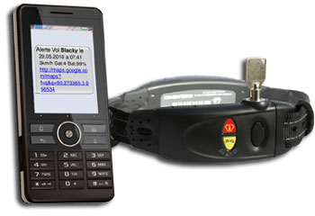
Tracking dogs - CollierGPS
Fri, 12/10/2010 - 01:23 — mdeweerd Collier GPS
When I discovered about 'Kookoo', the tracked cat back in May, I had no idea that I was going to work on a project to track dogs. And yet, I did.
If you are interested in this amazingly well designed collar, you can find more information in French at http://www.colliergps.fr and a demonstration of the interface, but here is my story: