height
Feature request: height/speed diagram
Wed, 01/13/2010 - 10:39 — SultanHi,
I'm new to GPS tracking and BT747. I got my iBlue 747A+ recently and I'm really happy there is such a good crossplatform OSS tool I can use.
Anyway, there might be a feature that BT747 not have but what would be nice to have: a diagram of hight/speed to time. The enclosing Windoze tool "GPS Photo Tagger" has such a feature (apparently - I didn't try it out: click).
The height correction 'corrected' ;-).
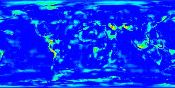
 BT747 corrects the altitude/height logged by the logger to an altitude with as reference the mean sea level. Stefano complained that this correction was not precise enough. The error can indeed go up to more than 40 meters in some locations. That is because the 1.X versions use values at the crossing of a 10°x10° grid fitting of the world. Following our fruitfull discussions, Stefano extracted the 1°x1° grid data. The differences with the 10°x10° model is shown in the picture.