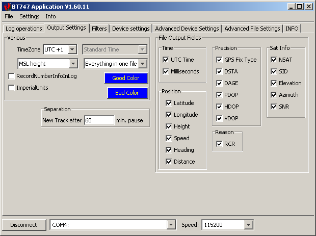
Output Settings Panel

| Various | |
|---|---|
| TimeZone: | The time offset that is to be applied to the time in the source log file. If the TimeZone is set to UTC+1 and the time in the input file is 12:35, then the time in the output file will be 13:35. There are some execeptions which can be controlled in the Advanced File Settings. |
| Keep WGS84 height MSL Height: |
MSL stands for 'Mean Sea Level'. The heights (altitudes) in the Logger are recorded using a reference called 'WGS84'. This is a reference supposed to be close the Earth's "surface", but it is not perfect. As human beings we are used to refer to altitudes by taking he Sea Level as a reference. By setting this option to 'MSL Height', BT747 will apply a correction to the height found in the input file. The correction corresponds to the difference between the modeled Mean Sea Level and the WGS84 Elipsoid. |
| Record Number Info in Log: | When active, the positions are numbered and that number is written into the output file. by de-activating this option, you can make the output files smaller. |
| Imperial Units: | The English had their proper units and they still use them! Clicking this option will make metrics appear as inches, miles, miles per hour, etc . |
| Good Color: | The color that is used in the HTML and KML output formats to indicate the track segments that correspond to valid positions. |
| Bad Color: | The color that is used to indicate segments with positions that were not selected. Example: when going through a tunnel, the device would log some invalid positions - invalid being no fix, PDOP to high, ... (according to the filter settings). That part would be shown in the 'Bad Color'. |
| File Output Fields and Items A further restriction of the information written to the output file. |
|
| You might log more fields than you want to find in the final output file. For example, you might choose to log HDOP and NSATs to be able to filter imprecise positions. If you do not want that information in your KML output file, uncheck them here. These values are still used for filtering, but not written to the KML file (works for other formats as well). | |
| Most fields: | Same significance as the log format explained elsewhere. |
| Add Track Point Info: | Adds the same information to track points as to way points. This will make the file bigger, but all information will be in it. If unselected, only way points have full information. |
| Add Track Point Name: | Give a name to eacht trackpoint. In Google Earth this will show a label for each track point when the track point list is opened. This will help locate the trackpoint you want to show. If unselected, this list will have empty labels. If Both 'Track Point Info' and 'Track Point Name' are disabled, individual track points will not be logged to KML output. This makes that output a lot smaller. |
| Separation | |
| New Track After ...: | Indicates the time separation required between two successive position to start a new track. For example, if this value is set to '60 min' then if your device did not log any position for 60 minutes, the next position will be the start of a new track. New tracks can result in separate files or in separate sections in certain formats (like a KML file). |
| Element: | Element description. |
- Printer-friendly version
- Login to post comments
- Deutsch
Comments
Time Zone
Time Zone value should not be integer only
Like Nepal is GMT+5.75
MSL/ WGS84: Automatic
But what does 'automatic' height do, convert MSL to WGS84 and vise versa
Automatic height
Some of the functionality in the 'development' version are indeed not documented yet.
The automatic height will convert the height according to the format.
If the source format is CSV and the destination format is CSV, the height value will remain the same.
Basically each file format is associated with a reference and the conversion is done depending on the source and destination reference, while the other settings are forced conversions.
Here is the list of associations as defined in the code (NMEA is WGS84 because the sum MSL + GEOID is considered):
{ Model.CSV_LOGTYPE, BT747Constants.HEIGHT_WGS84 },
{ Model.TRK_LOGTYPE, BT747Constants.HEIGHT_MSL },
{ Model.KML_LOGTYPE, BT747Constants.HEIGHT_MSL },
{ Model.PLT_LOGTYPE, BT747Constants.HEIGHT_MSL },
{ Model.GPX_LOGTYPE, BT747Constants.HEIGHT_MSL },
{ Model.NMEA_LOGTYPE, BT747Constants.HEIGHT_WGS84 },
{ Model.GMAP_LOGTYPE, BT747Constants.HEIGHT_MSL },
{ Model.TRL_LOGTYPE, BT747Constants.HEIGHT_WGS84 },
{ Model.BIN_LOGTYPE, BT747Constants.HEIGHT_WGS84 },
{ Model.SR_LOGTYPE, BT747Constants.HEIGHT_MSL },
{ Model.KMZ_LOGTYPE, BT747Constants.HEIGHT_MSL },
{ Model.ARRAY_LOGTYPE, BT747Constants.HEIGHT_MSL },
{ Model.MULTI_LOGTYPE, BT747Constants.HEIGHT_WGS84 },